
The setting
An operations and maintenance portfolio across multiple sites, sampled as the first events of a portfolio-wide monitoring program.
The obligation
Client standard calling for soil sampling at preconstruction baseline, in the first operational year, and at set intervals through the operational life, before decommissioning, and again after. Vegetation recorded annually for the full project lifecycle.
The constraint
Comparability. Data gathered once is a snapshot. Data that must mean the same thing in year twenty as it did in year one, across multiple sites, collected by field crews who were not present when the program was designed, presents a different problem. Sources of drift are closed at the procedure stage, where closing them is efficient, rather than at the reporting stage, where it is not.
What we produced
Verdelora developed and implemented the field procedure.
Sample locations are set by randomized point stratification in GIS rather than by field judgment, removing observer bias. Every point is permanently fixed and georeferenced on the first visit, then reoccupied at every event after. Each year is compared against the same ground.
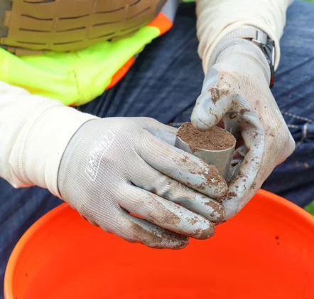
Physical and chemical samples are paired at each point and kept separate through transport. Bulk density is sampled with a known volume at a fixed depth. Soil health cores are composited from multiple subsamples at a set depth.
One laboratory, one method set, every event.
Vegetation is recorded in a fixed quadrat at the same coordinate, scoring the same variables in the same order every time: species present, cover by species and by functional group, ground cover by component, counts for seeded and noxious species, and height by layer. Every quadrat is photographed from a fixed height, and every frame carries its coordinate. The photo record is repeatable, allowing for comparison.
Deviations are recorded rather than smoothed over. Recorded conditions are what let a reviewer separate a real change from a wet week.
Results feed a structured database and standardized technical reports, which makes year one queryable in year twenty.
Where it stands
Baseline and first-year events are complete, with all points marked and georeferenced. Vegetation is recorded annually and soils are sampled at ascheduled interval, against the same procedure and the same laboratory. The next event is scheduled.